Marine - Environmental Optics Laboratories & Remote Sensing Center

March 13, 2011 AM & PM Mapping Camera Imagery
Home
Fluid Mud Flux SONDES
SEBASTIAN FIND Project Imgery, Fluid Mud Movement SONDES - How they work
Indian River Lagoon & Near Coastal Water Images & Hyperspectral Signatures: Methods - Instruments
About Us
View Our Brochure
Our Services
Projects
Location
Contact Information
Meet Our Staff
Current Research Info & Airborne Remote Sensing Images - BP Oil Spill Images
Research Summaries
International Society for Optical Engineering (SPIE) Publications
Papers
Hyperspectral Image Fusion with Aerial Photography

Scanned Photogrammetric Imagery Snapshots. Full Resolution Imagery Provides Approximately 255 Megapixel RGB Images Taken With Avipot Color X400 PE1 Negative Film taken at 3,000 ft Altitude with 12 inch Camera Focal Length, Image Scale: 1/3000  Scanned RGB Images with effective ~2-3 cm GSD.

agfaspectralcurve.jpeg

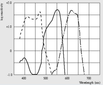
Spectral Sensitivity Curve of X400 PE1 Aviphot Color Negative Film

Enter content here

bpm103133ke001sm.jpg
Middle Big Lagoon, FL. 30°19'4.55"N, 87°21'3.19"W

bpm103133ke002sm.jpg
Middle Big Lagoon, FL. 30°19'3.57"N 87°20'51.16"W

Enter supporting content here

Dr. Charles Bostater
321-258-9134