|
|
 |
|
See What
the Sondes Measure by viewing the videos below ! Measurements of particles and flocs (muck and fluid mud) movement in & around dredging
sites using directional mass flux (mg cm-2 sec-1) instrument probes or Sondes
and particle velocimetry, airborne and bottom hyperspectral images & spectra. Transect and station data. See the images
below and the articles referenced below to see muck and fluid mud, the sondes - what
they measure and how they operate. The Sondes are probes and are used in conjunction with in-situ BRF targets and shallow
water gravity wave measurement devices originally designed and published in an article by Dr. Bostater, during the Spring
of 2014). The sondes measure the mass flux (g m-2 day-1) of moving muck and
fluid muds in the bottom boundary layer in aquatic systems. When deployed as vertical arrays they quantity the actual bedload
movement (flux) of fine grain particulates that cannot be measured using traditional water sampling techniques. Recent Peer
reviewed articles: Design and Operation of Sonde Arrays to Measure Fluid Mud in the Marine Environment, ISOPE
June 2017, ISBN 978-1-880653
Click here to download the above article
Charles R. Bostater, Rotkiske, Tyler, 2016, Fluid
Mud Sondes & Acoustic Imaging Methods for Coastal Dredging, ISOPE ISBN 978-1-880653-88-3, 7 pp.
Click here to download the above article
Rotkiske, Tyler, Bostater, R. Bostater
Jr., 2016, GIS Mapping of Fluid Mud Transport Pre Dredging-, During, and Post-Dredging Agitation, by using Engineered Novel
Instrumentation, ISOPE ISBN 978-1-880653-88-3, pp 1542-1547.
Click here to download article
Bostater, Jr., C R., 2016, A new multispectral imaging instrument for in-situ characterization of flocs & colloidal
aggregates in natural waters, SPIE Vol. 9862, pp. 98620k1-10. The above paper describes the operation, design and deployment results of
a "floc camera" designed and built by Dr. Bostater. It is used in conjunction with maintenance dredging research
in the Indian River Lagoon. The deployment showed how to use acoustic velocity current meters (MAVS) in conjunction with other
acoustic sensors, and underwater cameras and sondes. Results demonstrated the resuspension and movement of muck and fluid
mud associated with internal waves in the moving lutocline. The floc camera allows one to see and quantify the movement of
"estuarine snow".
Click here to download the above article
|
|
|
Bostater, C., R., Rotkiske, T., 2015, Moving fluid mud sondes, optical and
acoustic sensing methods in support of coastal waterway dredging, SPIE Vol. 9638, pages 96380F1-17. This reviewed paper describes and compares methodologies for fluidized mud and
muck sampling and shows results from use of the sondes to compare pre, during and post dredging flux measurements in Indian
River Lagoon. The theory behind how the sondes work in the lutocline and pictures of the Sondes are also shown in this paper.
Click here to download the above article
Bostater, C., 2014, Shallow
water surface gravity wave imaging, stereo sensing, spectra and their operational use in shallow water dredging operations
and planning , SPIE, Vol. 9240, 12 pp US EPA, 1982, Chesapeake Bay Program Technical Studies: A Synthesis, Wash. DC, 636 pp. Bostater, C., Ambrose, B.,
Bell, B., 1981, Modeling the fate and transport of chemicals in estuaries: current approaches and future needs, In: ASTM (American
Society of Testing and Materials) STP 737 Aquatic Toxicology and Hazard Assessment, pp 72-89. Anonymous, 2012, Indian River Lagoon 2011 Superbloom Plan
of Investigation, 26 pp.
Reviewed publication for SONDES and their use
during the spring and summer of 2014:
Bostater, C., Yang, B., 2014, Shallow Water Surface Gravity Wave Imaging,
Spectra and Their Use in Shallow Water Dredging Operations,, SPIE, Vol. 9240, pp. 92400k1-9. The above reviewed article shows how the sondes were first used in conjunction with wind driven water
wave gauges to demonstrate that muck and fluid mud is suspended and moves during high wind conditions. This research
continues in the Indian River Lagoon and Banana River using vertical arrays of the sondes during deployment with water wave
video analysis.
Click here to download the above article
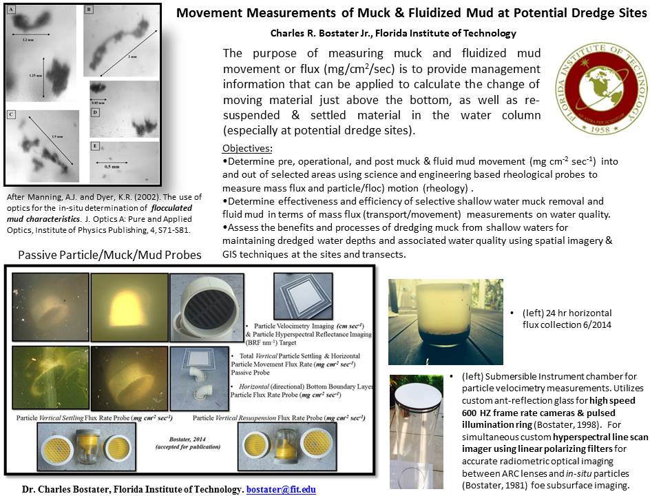
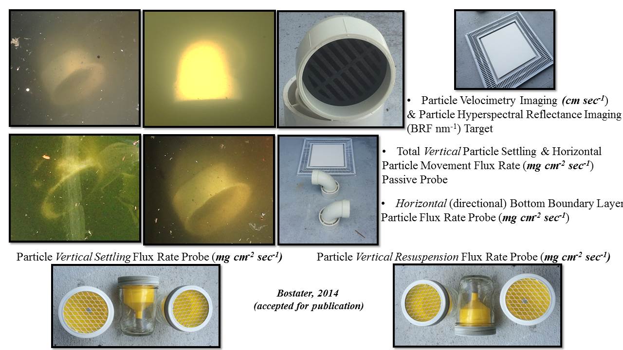
| Custom mass flux horizontal & vertical probes |
|
|
| Probes & In-Situ Hyperspectral Targets (Bostater, 2014) |
|
|
|
|
|
|
|
|
|
|
|
|
|
|
|